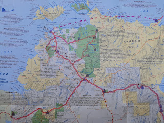
Cape York (Cairns to Darwin)


In 1997 Helen gave me a book about Cape York with the inscription "In anticipation of further adventures with a Land Rover". Cape York was a lot more difficult to get to in the 1990s and we never accumulated enough holiday leave to make the 7000km return trip from Sydney. We sold that Landy in 2002 as there was no room for baby Carl.
In a different Landy, and having left an adult(ish) Carl in Sydney, we finally made it!
Our time in Cairns was spent driving around various shops to restock, and we didn't bother taking any photos. We then headed north to rainforest and Port Douglas.
There used to be a tree in there but it's now just the strangler vines and loads of epiphytes.


The main ocean beach at Port Douglas. We camped just behind the palm trees (I can't tell you exactly where in case the council decides to fine us).


There's loads to see on the Cape and we were having trouble deciding when to go to different places. So we decided that when heading up & down the Cape we would only visit places on the right-hand side of the main route. We headed up the Bloomfield Track (more a sometimes-very-steep dirt road than a 'track').
Some cool beaches.


Wujul Wujul Falls

The estuary at Cooktown. After the Endeavour accidentally ran into a bit of the Great Barrier Reef in June 1770 and nearly sank, Captain Cook beached the ship on these sandbanks. It took them 7 weeks to fix it and then another week or so to get moving again due to unhelpful winds and (understandable) nervousness about running aground again.

After a quick stop in Cooktown for coffee, fuel and food we kept right and headed through Lakefield National Park and the Lama Lama lands. Awesome creeks and lagoons / lakes and wildlife.
Isabella falls - Adam was in charge of checking for crocs.


Another lagoon full of lilies


We camped at Port Stewart. Despite the name there is no longer a port - in the 1890s it was used for supplies and for migration (especially by Chinese miners) to gold mines at Coen, which is 80km inland. The land is indigenous-owned but only a few people live there - someone said that most of the shacks are used for fishing trips by people who live in Coen.

Somewhere in Lakefield NP


More creek crossings

Away from the lagoons it was pretty dry.

We camped next to the river. Someone else there went fishing that evening and caught something big, but it got nicked by a couple of crocs before he got it in. Helen got thoroughly eaten by sand flies.

We headed out to the Lockhart River settlement. We spent a fair bit of time at the local art co-op chatting to Aunty Irene. After we left we saw her picture in loads of FNQ tourism brochures - she's travelled all over Europe to exhibit her artwork.
Swimming spot in the Wenlock river next to one of our campsites.
More lagoons
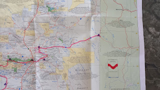
Once you get to Bramwell there are two main routes north - the Peninsula Development Road (PDR) and the Old Telegraph Track (OTT). The PDR is a maintained dirt road with some of Australia's biggest corrugations and a few tarmac sections. The OTT is 4WD only, varying from easy to difficult. With the camper on the back of the Landy making it pretty heavy and a bit tippy, and not wishing to break anything, we decided to travel mainly on the PDR and drove only a few sections of the OTT.

A couple of other vehicles then winched him out of the hole. (Despite what it looks like there were actually quite a few people around - they are all just suitably wary of winch cables breaking and standing well back).
Along the track are some awesome creeks with croc-free swimming holes, eg Fruit Bat Falls:

Cool creeks
Copulating snakes
Camping
Dirt roads - no need for corners, just draw a straight line on the map and off you go!


One of the creek crossings on the OTT - not nearly as deep as the ones we didn't do.
There are some seriously large termite mounds!

Crossing the Jardine river by (very expensive) ferry


The last bit of road to the tip - yet more muddy creeks, and beautiful rainforest

And finally to the top of the Australian mainland! And yes, there is land behind us but it's a couple of islands.
We headed south again and, in line with our "keep right" plans, headed to Weipa. This is a large town due to the massive bauxite mine. Rio-Tinto have a policy that employees must live in Weipa (rather than fly-in, fly-out) and they supply heaps of services etc. Supermarket prices were the same as in Sydney rather than having a 50-80% premium!

We went on a boat cruise to see some crocs and a pretty cool sunset across the water. (A rare thing when you live on the east coast.)


Burn-offs are a huge part of land management in the top-end, especially at this time of year as the grass is dry enough to burn nut not so dry as to create a massive fire. Note the eagles etc flying above the fire to catch grass hoppers, snakes etc.

The last bit of this road crossed the Mitchell River. There is a firm plastic base on the ford but most of the width is covered with sand each wet season that then has to be dug out again. It's about 200m through the dug-out sand and then 100m across the flowing bit of the river. I waded across to check the depth and chatted to the contractors on the other side who were still moving sand - they kindly let me know there were often crocs in the area...
Half way across - it was only knee deep so no great drama

Swimming spot in the Wenlock river next to one of our campsites.
Once you get to Bramwell there are two main routes north - the Peninsula Development Road (PDR) and the Old Telegraph Track (OTT). The PDR is a maintained dirt road with some of Australia's biggest corrugations and a few tarmac sections. The OTT is 4WD only, varying from easy to difficult. With the camper on the back of the Landy making it pretty heavy and a bit tippy, and not wishing to break anything, we decided to travel mainly on the PDR and drove only a few sections of the OTT.
About 6 km along the OTT we realised this was a good choice when we came across a Toyota with a broken front diff and burnt-out winch stuck in a deep muddy creek crossing.
We carry an old-school hand winch (simple, light, portable, versatile - just saying) and pulled him back to the creek bed so he could turn around. (Because it was my winch I got to supervise while a much younger bloke did the hard work!)
A couple of other vehicles then winched him out of the hole. (Despite what it looks like there were actually quite a few people around - they are all just suitably wary of winch cables breaking and standing well back).
There were a couple of easier ways across the creek, which the other vehicles all took!
Along the track are some awesome creeks with croc-free swimming holes, eg Fruit Bat Falls:
Carnivorous plants
Copulating snakes
Camping
Dirt roads - no need for corners, just draw a straight line on the map and off you go!

Trying to get a good view

Lots of very dry bush
One of the creek crossings on the OTT - not nearly as deep as the ones we didn't do.
There are some seriously large termite mounds!

In other places there are heaps of small ones
Crossing the Jardine river by (very expensive) ferry

Late afternoon on the beach. Incredible scenery but you can't swim because a croc might like something to nibble on. (We saw their tracks on this beach)


More coastline

And finally to the top of the Australian mainland! And yes, there is land behind us but it's a couple of islands.

We headed south again and, in line with our "keep right" plans, headed to Weipa. This is a large town due to the massive bauxite mine. Rio-Tinto have a policy that employees must live in Weipa (rather than fly-in, fly-out) and they supply heaps of services etc. Supermarket prices were the same as in Sydney rather than having a 50-80% premium!
You can pick up bauxite on the beach if you want to try a bit of aluminium smelting
We went on a boat cruise to see some crocs and a pretty cool sunset across the water. (A rare thing when you live on the east coast.)


Evening entertainment is limited so we ended up at the go-cart races with some friendly locals. It's a really well-equipped facility - apparently Rio wanted to mine under the old track and the club president was clearly a good negotiator!
I also changed the air filter now we were off the worst of the dusty roads

We headed south again on the way west towards Darwin. We took a shortcut on the Dixie road - this is about 500km shorter that the main route but road conditions were a bit of an unknown. Turned out to be 80% fine, 20% terrible.
There was an old gold mine half way, worked from the mid 1800s, mid 1900s and early 2000s (and about to restart).


Burn-offs are a huge part of land management in the top-end, especially at this time of year as the grass is dry enough to burn nut not so dry as to create a massive fire. Note the eagles etc flying above the fire to catch grass hoppers, snakes etc.

Free camping a few hundred meters off the road
The last bit of this road crossed the Mitchell River. There is a firm plastic base on the ford but most of the width is covered with sand each wet season that then has to be dug out again. It's about 200m through the dug-out sand and then 100m across the flowing bit of the river. I waded across to check the depth and chatted to the contractors on the other side who were still moving sand - they kindly let me know there were often crocs in the area...
Half way across - it was only knee deep so no great drama

As we headed west we stopped in Normanton and went through Lawn Hill NP and a few other small towns before heading into the Northern Territory.

Another shortcut - much more pleasant driving on the tarmac main roads!
More cool rivers

And billabongs

Creek crossings designed to prevent caravans taking the more interesting roads. We've crossed at least a 100 with water in and heaps more that were dry.

No need for corners!

Once we crossed into the Northern Territory we stayed in Limmen NP for a few days while we waited to see if the Darwin lockdown would end as scheduled.
Sandstone pillars in the "Lost City"

Turkey bush - beautiful tiny flowers.

Butterfly Falls, a spring-fed waterfall / swimming hole

complete with pretty waterlilies and paperbarks

The Roper River.


Your photos are fabulous Helen and your trip looks amazing
ReplyDeleteHooray - you made it to the Cape! Great update!
ReplyDelete