Week 3/4 - Deni to the Flinders Ranges via Cameron Corner


Mobile reception has been pretty patchy in the last week or so - we did buy a Telstra phone in Broken Hill (so we now have a full set) but even that doesn't work in the middle of nowhere,,,
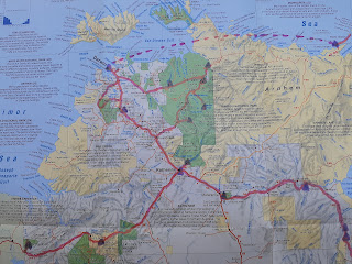
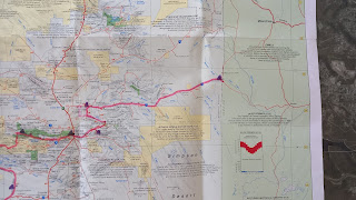
Note re our maps - these came free with the Australian Geographic Magazine in 1999/2000. They're not very up-to-date with regard to which roads are sealed etc, but not many places have moved since then. The pink line is our route with interesting places circled; purple triangles are where we stayed.
We ended up staying near Mathoura just south of Deniliquin for 2 nights. Deni is famous for its annual Ute Muster (which should be on again this year) and Mathoura is starting small with its Bra Fence. We met some people we knew at church on Sunday morning and ended up camping in their house paddock, which was very pleasant!
We were heading west with the intention of crossing into SA at Renmark and visiting the Flinders Ranges in SA before heading down to Adelaide. As the weather has been (and still is) relatively cool this year, this plan first evolved into heading north-west to Broken Hill, and then further evolved into heading all the way to Cameron’s Corner. As it turns out, cooler than normal is still very hot.
This 1500km detour took us from the Riverina, with irrigated rice paddies, through increasingly arid country into the ‘proper’ outback. (My memory of High School Geography says that most outback areas of Australia are arid zones and not technically deserts due the amount of rainfall they get, despite the names on the map.) As we travelled north the trees got smaller and then disappeared altogether, the grass paddocks gave way to sporadic grass and then salt bush, and the gaps between the vegetation grew. The ground is generally a combination of dust, sand, and rocks that are mostly red or black, but sometimes white. (It's a geology thing that I don't understand.) It’s rained recently so there is a lot of vegetation and from a distance it looks very green, but there's very little water. We’ve driven through hundreds of creek/river beds with 2-week-old flood debris up to 4 meters high, but we haven’t seen any flowing water north of Menindee.
We visited Lake Mungo, where the approx 40,000 year-old human bones were discovered in the 1960s and, more recently, some 20,000 year-old footprints. For some reason this area is shown as a perenial lake on maps, even though it hasn’t been full of water since the last ice age. Perhaps that’s a surveying joke, but apparently people sometimes arrive with their canoes!
We spent a couple of nights in Broken Hill and visited a couple of great art galleries (Pro Hart & the Broken Hill Regional Gallery). We also found a really good coffee shop in the town centre, visited the local history museum and the RFDS base, and had the car serviced.
We stopped at the only townships on the 330km stretch between Broken Hill and Tibooburra - the Packsaddle Roadhouse and the pub at Milparinka (population 7, down from 3000+ in its Gold Rush heyday in the late 1800s). Super friendly people in both places. Tibooburra, the township furthest NE in NSW, is a lovely spot and popular with tourists in the cooler months. With a population of less than 100 they have 2 pubs (one of which just burnt down), a petrol station/ cafe and a shop. (All owned and run by women.) In the not-burnt-down pub we met a 70+ year old bloke who was the captain of the RFS and SES and does the weekly garbage run for the town and loads of other stuff. He was on a motorised scooter with a leg brace on, the result of an exploding gas bottle when trying to put the fire out in the other pub. Sounds like he (and 2 other people) were lucky to survive - he was evacuated to Adelaide by the RFDS before returning to town to be treated at the weekly RFDS clinics.
After Tibooburra we headed, via the back roads, to Cameron's Corner, aka the intersection between NSW, Queensland and SA. The name comes from the surveyor who, starting in 1879, was tasked with drawing a line in the sand so everyone could tell where the north-western bit of NSW ended and Queensland started. This took 2 years and resulted in a boundary peg at the corner of the states with his name written on it. (No mention of his mates.) I would have called it “Hot and Dusty and Why Do All The Flies Live Here Corner”. After spending an hour in Queensland at the roadhouse having instant coffee and chips and chatting the the couple who run it (they arrived two years ago for a “sea change”), we headed into SA. (Fun fact - the woman behind the counter answers with phone with “Karen at Cameron’s Corner”. Sadly, her husband is not called Kevin.)
Heading west across the Strzelecki desert was like a roller-coaster ride, with the road going over a 14m high sand-dune every 200m or so. We headed south on the Strzelecki Track, which isn’t a ‘track’ any more but a well-maintained 20m wide dirt road. We camped in a dusty ‘campground’ that was really just a designated area between the sandhills. Incredibly beautiful but too many flies so we ate inside the camper for the first time.
After heading further south and west we saw hills again after 1500km of flatness! We’ve now travelled the length of the Flinders Ranges to the resort at Wilpena. (A resort in outback-speak can mean all sorts of things, from a hotel with modern swimming pools through to 1980s-era portacabin toilet blocks next to a dusty campsite. Wilpena is somewhere in the middle - the small pool was lovely.) The scenery is stunning, with deep gorges and amazing hills with millions of years worth of rock strata sitting at a interesting angles.
From here we’re heading south towards Adelaide by the end of the week and then on to Melbourne a week or so later.
Photos.....
Letting it all hang out on Mathoura's bra fence


Comments
Post a Comment